The Shire of Kent is located in the Great Southern of Western Australia approx 320Km from Perth, it is made up of two towns Nyabing & Pingrup. The Shire covers approximately 5634 square Kms and is predominately an agricultural area with many Wheat & Sheep farmers. To find out more on the Shire of Kent Facts, Figures and Statistics follow this link to Shire Statistics.
Councillors are elected from both communities every two years, their role is represent the people within our Shire. To see the current Councillors serving our community follow this link to Councillors.
Both communities within the Shire of Kent hold events throughout the year.
Nyabing & Pingrup are both rich in local history, with Gnamma Holes, Pink Lakes, Old Schools and Landmark Sites.
Towns
Information collected from WIKIPEDIA & ALBANY GATEWAY
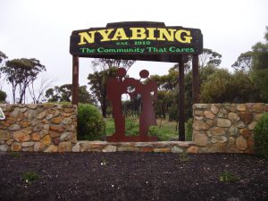
Nyabing – “The Community That Cares”
It is believed that the word NYABING is from Aboriginal origin and is thought to be derived from the Aboriginal word “ne-yameng”. Which is the name of an everlasting flower Helipterum manglessii.
The townsite was planned in 1911 as part of the Great Southern Railway. The name given to the siding was Nampup. The name Nampup is also of Aborginal origin and is the name of a loacal soak. Lots were surveyed later in the year and the town was gazetted in 1912. The name was changed later that year after several complaints that Nampup was too similar to the town named Nannup, so the town was renamed to Nyabing.
Pingrup – Small Town, Lots of Spirit “Where Lakes and Good Friends Meet”
The name of the town is also of Aboriginal origin as are many of the rural town names in the Great Southern area. Pingrup was the name of a lake that is close to the townsite. The meaning of the word is unknown, the name first appeared on the charts of the area in 1873.
In 1923 the railway line was extended easterly from Nyabing to Pingrup and the district surveyor had had land surveyed for a townsite at the railway terminus. When the name of the railway was being decided the railways department though Pingrup was too similar to Tingerup and suggested “Geina”, a name which had been used for the area around 1900. The name was not acceptable to local settlers, who proposed ‘Lake Pingrup’ as an alternative. However, the lands Department decided that Pingrup was a more desirable name and not too similar to Tingerup afterall.
